Florida could see a Category 2 hurricane hit next week, bringing surge and high winds to the recovering west coast and serious flood risks to South and Central Florida.
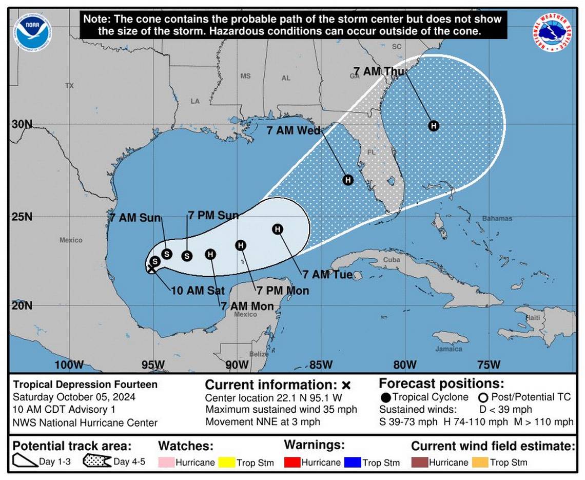
The National Hurricane Center’s first cone of uncertainty for Tropical Depression 10 puts it on an eastward path through the Gulf of Mexico and into Florida’s west coast on Wednesday — a second blow for a region still catching its breath from the devastating Category 4 Hurricane Helene.
Forecasters said the tropical depression could strengthen into Tropical Storm Milton as soon as Saturday afternoon and into a hurricane on Monday.
Where the eye will come ashore is hard to predict this far out and will continue to shift. The latest track takes it onshore just south of Tampa Bay, across Bradenton.
But all of South Florida will feel impacts from this storm, regardless of where it makes landfall.
The major threat from this storm is flooding. It will be a risk for places far outside the direct path of the storm and the cone.
Parts of Florida were already getting drenched on Saturday, a trend expected to continue through Tuesday and enough to cause flooding on its own. Miami-Dade and Broward County were already under flood advisories Saturday morning.
Already soggy ground will flood even faster with just a little bit of water. The new system is expected to bring heavy rains over the southern half of the state.
“Best way to think about it is that Florida will see a one-two punch. The first one will bring us rain Sunday into Monday with an area of low pressure along a stalled out front. Then the 2nd, main punch from tropical storm or hurricane approaches on Tuesday into Wednesday,” Matt Devitt, chief meteorologist for Southwest Florida’s WINK news, posted on Twitter.
High winds
The current forecast calls for the storm to strengthen to a Category 2 hurricane by the time it reaches Florida, with 110 mph sustained winds.
That’s enough to bring storm surge to the West Coast — again.
“Even if this doesn’t realize a high end wind core, it will have the potential for significant surge inundation,” Andrew Moore, a meteorologist for Arch Reinsurance, wrote on Twitter.
The strength of the storm at landfall depends on what happens to it on the way. One factor in favor of strengthening is the warm waters of the Gulf, which didn’t cool off very much after high-speed Helene churned through two weeks ago. Sea surface temperatures, or SST, are above normal for much of the Gulf.
“Most of the Gulf is above average SST still, and the loop current is prominent. Shelf south of Tampa is extremely warm as well. Lots of potential fuel,” wrote Andy Hazelton, an associate scientist at the hurricane research department at NOAA, on Twitter.
Kieran Bhatia, senior vice president at reinsurance firm Guy Carpenter, called it “the red carpet treatment for rapid intensification.”
“Milton will experience a sea surface temperature and potential intensity environment that is rarely seen during September (let alone October,” he posted on Twitter.
The National Hurricane Center explicitly calls for rapid intensification on Monday, when the storm is expected to become a hurricane,